Friday, 7 December 2012

Blog 245

Monument Valley - Sunrise Tour 24th May 2012
We had to be awake at 3:30 am to be able to travel from our hotel in Kayenta to the View Hotel in Monument Valley to meet our Navaho guide Ray at 4:45. Ray is part of the Kéyah Hózhóní Navajo native american guiding company. Website here. He took us into the private areas and we drove in his pick-up for half an hour to where we could view the sunrise between the 450 feet high Totem Pole and Yei Bi Chei meaning Navajo spiritual gods. It is located adjacent to the Totem Pole and is imagined as a formation of dancers emerging from a Hogan. I started to take these images just after 5:45am, the sun appeared at 6:10am.

Totem Pole and Yei Bi Chei
Sunrise - Totem Pole and Yei Bi Chei
Totem Pole, notice the outline of the native american head near the right base
Desert insect which just after it was seen it burrowed into the sand presumably to remove itself from the rising temperature.
Animal and reptile tracks.
Rattle snake tracks, our guide indicated that the rattler had past this way about ten minutes before we arrived
The Bog Hogan rock formation, looks like the outline of a Native American's head with flowing hair

Thursday, 6 December 2012

Blog 244

Goosenecks
Located just outside of Blanding, Utah, four miles from highway 261 on county road 319.

On its way to the Colorado River, the sediment rich water of the San Juan river meanders through Gooseneck State Park, creating deep canyon chasms.  The park is only 10 acres and within that area, five miles of river flow in serpentine fashion to reach the Colorado River only 1 linear mile away.

Goosenecks

Bluff Utah
Bluff is a small town located in the San Juan River Valley in the south eastern corner of Utah. Located along U.S. Highway 191, Bluff is bordered on the south by the San Juan River and the Navajo Nation.

No white settlers called the Bluff valley home until 1878. Historic Bluff City was founded in 1880 by the famous "Hole in the Rock" expedition of Mormon (Latter-Day Saint) pioneers, whose mission was to establish an agrarian community on the San Juan River. The original fort and historic village of log homes was laid out with the church, school, and co-op store in the centre  and was surrounded by agricultural fields and orchards. Farming along the San Juan River proved uncertain, for the river either flooded or went dry too often for dependable irrigation.

Modern Bluff - Visitor Centre
Inside the Barton family cabin with earth sod roof
Covered wagon based on that used by the early settlers

Sunday, 14 October 2012

Blog 243

Photographs taken in Canyonlands National Park, Utah, 21 May 2012

Canyonlands is a wilderness of countless canyons and fantastically formed Buttes carved by the Colorado River and its tributaries. Rivers divide the park into four districts: the Island in the Sky, the Needles, the Maze and the rivers themselves. These areas share a primitive desert atmosphere, but each offers different opportunities for sightseeing and adventure.

Monitor and Merrimac Buttes
Shafer Canyon Overlook With Shafer Trail Road
Mesa Arch
Panoramic view through Mesa Arch towards the La Sal Mountains
View from Buck Canyon Overlook
Zoomed in view from Buck Canyon Overlook, La Sal mountains in the distance

Blog 242

Photographs taken in Capitol Reef National Park, Utah 19/20 May 2012

Located in south-central Utah near Torrey in the heart of red rock country, Capitol Reef National Park is a hidden treasure filled with cliffs, canyons, domes and bridges in the Waterpocket Fold, a geologic monocline (a wrinkle on the earth) extending almost 100 miles.


The Fruita Schoolhouse opened by Mormon settlers in 1896, closed in 1941 due to declining enrolment

Photographs taken in Arches National Park, Moab, Utah, 20/21 May 2012

We discovered a landscape of contrasting colours  landforms and textures unlike any other in the world. The park has over 2,000 natural stone arches, in addition to hundreds of soaring pinnacles, massive fins and giant balanced rocks.

Three Gossips
Balanced Stone (note the people to the right to give scale to the stone)
Tower of Babel and The Organ (note my companion standing to the left front of the formation)
Delicate Arch 65-foot (20 m) tall (note my companion standing to the left of the formation)
Fiery Furnace is a collection of narrow sandstone canyons

Thursday, 27 September 2012

Blog 241

Photographed on the journey from Torrey to Moab, Utah 20th May 2012


Factory Butte adjacent to U24
Rock formation adjacent to U24


Blog 240

Visited and photographed here on 17/18th May 2012

Bryce Canyon which, despite its name, is not a canyon but a collection of giant natural amphitheatres along the eastern side of the Paunsaugunt Plateau. Bryce is distinctive due to geological structures called hoodoos, formed by frost weathering and stream erosion of the river and lake bed sedimentary rocks. The red, orange, and white colours of the rocks provide spectacular views for visitors. Bryce sits at a much higher elevation than nearby Zion National Park. The rim at Bryce varies from 8,000 to 9,000 feet.


Detail in Bryce Canyon in early morning light

Blog 239

Visited and photographed in Zion National Park 16/17th May 2012

Zion National Park is located in the South-western United States, near Springdale, Utah. A prominent feature of the 229-square-mile park is Zion Canyon, which is 15 miles long and up to half a mile deep, cut through the reddish and tan-coloured Navajo Sandstone by the North Fork of the Virgin River.


Blog 238

Visited and photographed these features on 16th May 2012


Horseshoe Bend is the name for a horseshoe-shaped meander of the Colorado River located near the town of Page, Arizona. Accessible via a ½-mile hike from U.S. Route 89, it can be viewed from the steep cliff above. According to Google terrain maps, the overlook is 4,200 feet above sea level and the Colorado River is at 3,200 feet above sea level making it a 1,000 foot drop.
Rock strata adjacent to the Horseshoe Bend

Coral Pink Sand Dunes State Park encompasses 3,730 acres of south-western Utah. Established in 1963 with land acquired from the Bureau of Land Management (BLM) to serve as access to the dunes for recreation, and to protect the dune resources.
At an elevation of 6,000 feet, and 12 paved miles off U.S. Highway 89 near Kanab, Utah, this park provides a fantastic setting for camping, hiking, off-highway vehicle riding, taking photographs or just playing in the sand.

Rippling arcs of rust-coloured sand welcome you as you enter Coral Pink Sand Dunes State Park. Contrasted by blue skies, juniper and pinion pines, and steep red cliffs
Details from the far from benign desert 

Sunday, 2 September 2012

Blog 237

Two photographic expeditioners left the UK on 11th May 2012 for a two week Photographic tour of parts of Arizona and Utah


Ford Explorer - Our Chariot for the expedition
La Quinta Inn ,Phoenix, AZ- Our first hotel
Rock Formation Nr Sedona, AZ
Chapel of the Holy Cross, Sedona, AZ
Meteor Crater is a meteorite impact crater approximately 43 miles (69 km) east of Flagstaff, near Winslow in the northern Arizona desert of the United States. Nearly one mile across, 2.4 miles in circumference and more than 550 feet deep
Little Colorado River Gorge  - providing the principal drainage from the Painted Desert region. The Gorge is located just north of the Cameron Trading Post about 52 miles north of Flagstaff, Arizona on Arizona Highway 89
Arizona - Highway 89
Upper Antelope Canyon Entrance - The Navajo name for Upper Antelope Canyon is Tsé bighánílíní, which means "the place where water runs through rocks". Nr Page, AZ.
Within Upper Antelope Canyon, Nr Page, AZ
Within Upper Antelope Canyon, Nr Page, AZ 
Dusk in Grand Canyon, AZ. The canyon has unique combinations of geologic colour and erosional forms decorating a canyon that is 277 river miles (446km) long, up to 18 miles (29km) wide, and a mile (1.6km) deep
Dusk - Grand Canyon, AZ

Friday, 29 June 2012

Blog 236

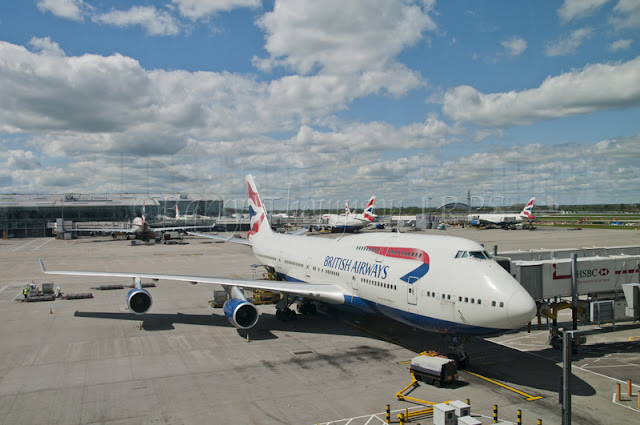
Our speed-bird which carried us to Phoenix, Arizona. 11th May 2012. Heathrow Terminal 5.

Boeing 747-400

Final engineering inspection before take off

Power-plant, wing and baggage transport